A new interactive map allows viewers to trace their hometown’s geographic shifts through millions of years of Earth’s history.

Earth, with its reassuringly familiar continents, didn’t always look like it does today. Once clustered together in supercontinents, its land masses have cracked and shifted away from each other, and repeatedly come together again during our planet’s 4.5-billion-year of history.
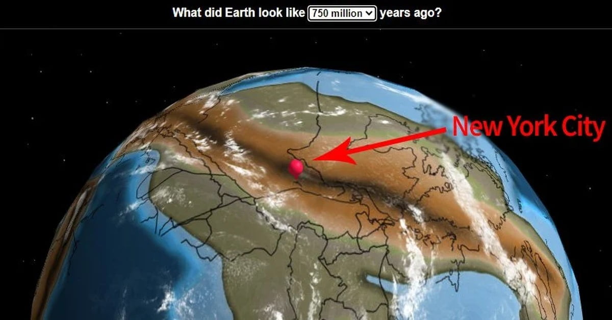
This means the actual location of your hometown has done more globetrotting than you have. And, thanks to a cool new interactive map entitled Ancient Earth, you can track how that location has shifted over the course of hundreds of millions of years.
The site is easy to use. You simply begin by dropping a pin in a location of your choice, or entering its name in the search box. Then you can choose from a range of dates going back to 750 million years ago and observe how the landmasses carrying their location have shifted, combined, and separated on Earth’s tectonic plates.

Launched a few years ago by palaeontologist Ian Webster, the interactive map is based on palaeogeographic maps developed as part of the PALEOMAPS project – led by geologist and palaeogeographer Christopher Scotese – and data from GPlates, an open-source repository of geoscience data.
“I’m amazed that geologists collected enough data to actually plot my home 750 million years ago, so I thought you all would enjoy it too,” Webster wrote in 2018.
“Even though plate tectonic models return precise results, you should consider the plots approximate (obviously we will never be able to prove correctness). In my tests I found that model results can vary significantly. I chose this particular model because it is widely cited and covers the greatest length of time.”
With the combined tool he developed, you can basically rewind Earth, stretching back as far as 750 million years ago. That’s not the entirety of the planet’s history, but it does encompass four supercontinents – Pannotia, Gondwana, Laurentia, and Pangaea.

A drop-down menu allows viewers to find monumental benchmarks in Earth’s history. For instance, the first land plants appeared 430 million years ago during the Silurian Period, when a mass extinction threatened marine invertebrates. Then, around 120 million years ago, the first flowers evolved – but not in all parts of the modern United States. A search of Sarasota shows that the state of Florida and the Gulf Coast remained underwater until some 35 million years ago.
The drop-down menu in the centre allows you to choose your own dates. In the upper left corner – and this is the part you’ve been waiting for – a text box allows you to input a location (e.g. your hometown) that you can then track across the ages, with present-day borders marked by black lines.

It’s fun to go back in time and see your hometown deep beneath the waves, or on top of gradually appearing mountain ridges. However, it also raises some more serious considerations.
When speaking to CNN about the project, Webster noted, “It shows that our environment is dynamic and can change.” He elaborated, saying, “The history of Earth is longer than we can conceive, and the current arrangement of plate tectonics and continents is an accident of time. It will be very different in the future, and Earth may outlast us all.”
Indeed, this amazing map is also a cool reminder that nothing – not even this beautiful planet of ours – stays the same.